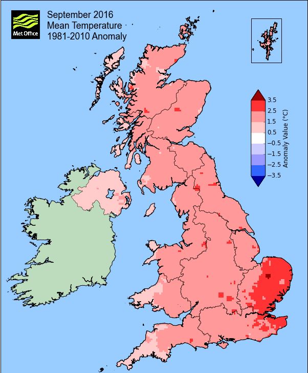
A notably mild month with night-time minima significantly above average - second warmest September on record.
Provisionally September 2016 was locally the second warmest on record to that of 2006. That warmth was most notable by night with the mean minimum temperature showing a departure of over 2° from the norm'. Both the 6-7th and 12-15th saw a feed of warm air from the south that resulted in temperatures well above the 20°c mark and which culminated in a sharp thunderstorm on the 13th.
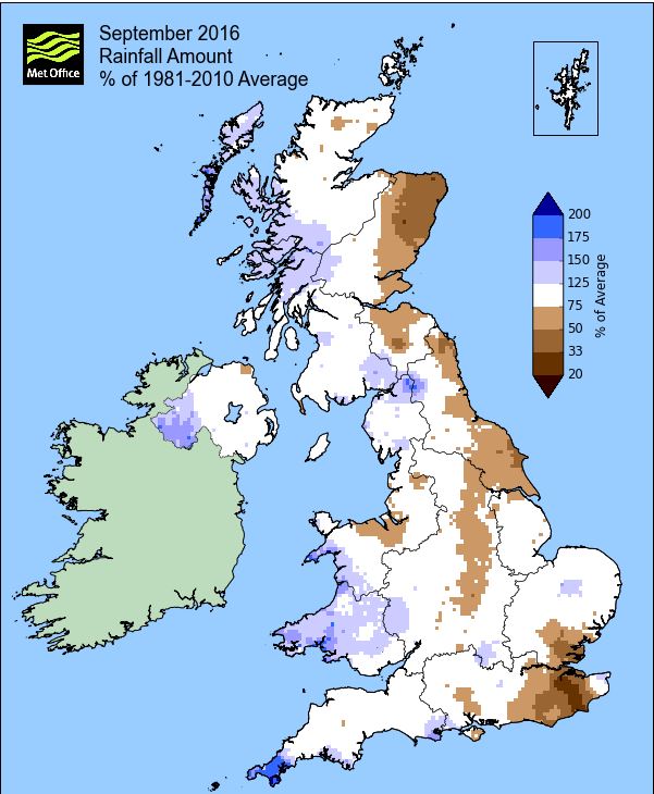
MSLP of 1014.9 Mb was +0.8 Mb above the local average for September with the month starting and finishing unsettled and whilst rainfall was never that heavy or prolonged, it was frequent.
Overall a mean minimum of 10.42°c and a mean maximum of 17.74°c saw the temperature 1.8°c above the 1981-2010 average and it was the warmest September since 2006 (the warmest of the 8 now recorded at this site). The highest maximum temperature recorded was 24.7°c (15th), the lowest minimum 4.3°c (17th). At Reagill the mean temperature was 13.9°c.
Rainfall of 99.6 mm (Crosby Ravensworth School 113.9 mm - CastleHowe Scar 112.5 mm and Reagill had 113.1 mm) made it the wettest September since 2012 (the 4th wettest of the 10 now recorded at this site) and was 132.3% of average for 2007-15. Locally, rainfall percentages were marginally above normal, hovering either side of 110%.
At the Met' Office site at Newton Rigg, 85.6 mm (112.2%) made it the wettest September since 2012 and in a series back to 1900 there have been 43 wetter and 71 drier (with incomplete data for 2 years). In a series back to 1951, a mean temperature of 14.3°c is the second warmest in that record.
Figures from the Environment Agency’s rainfall sites were, (figure in brackets being the monthly average for 1961-90) ‘Data kindly provided by the Hydrometry and Telemetry team of the Environment Agency (Penrith)’:
Kirkby Thore 60.6 (69.7 mm)
Brothers Water 265.47 mm (243 mm)
Nunwick Hall (Is still suspect data) (79.3 mm) and
334.2 mm at Seathwaite Farm (Borrowdale - 270 mm [average for 1981-2010])
1st - 5th A weak ridge of high pressure (HP) was over the UK on the 1st with low pressure (LP) in the Atlantic pushing a frontal system east overnight into the 2nd. Rainfall amounts were only slight, but a faster moving area of LP swept to the south of the first LP, arriving during the 3rd and bringing a wet day of 13.7 mm.
The LP of the 3rd then drifted NE to be replaced by another LP system on the 5th. Again rainfall was only slight, but the afternoon was a complete mix of drizzle, sun and murk and with the temperature steadily creeping up.
6th - 7th A feed of warm southerly winds then brought a couple of muggy days and exceptionally high overnight temperatures. At best we had a few sunny spells on the afternoon of the 6th and some weak sunshine on the 7th, but with either haze or murk in the muggy conditions on both days and after 21.1°c on the 6th the temperature rose to 23.5°c (74.3°f) on the 7th, but was it warm overnight.
Apart from the 1st night-time temperatures had been well over 10° every night and then the 6th recorded a minimum of 15.6°c, but the 16.3°c (61.3°c) overnight into the 7th is what the mean day-time maximum should be in September and both nights had been very uncomfortable.
8th - 11th LP had never been far away and was now centred just west of Eire. An associated cold front would now move east bringing a brief spell of heavy rain during the afternoon of the 8th (10.2 mm) and then introduced slightly cooler air with temperatures dropping back to 16.2°c (8th).
A new area of LP filled on the 9th and brought another spell of heavy rain during the 9th (14.3 mm - the month's wettest day) before the pressure gradient slackened and subsequently the 10-11th were quieter, drier days, although the best of any sunshine reserved itself for the evenings.
12th - 15th This period saw a return to hot and humid conditions as a feed of warm southerly air was drawn up. The 12th saw LP in the Atlantic being held at bay by HP over the continent, but a frontal system made very slow progress east with its cold front occluding and becoming semi static through the Irish sea. Subsequently the 12th was cloudy, but also quite dark at times, with the warmth and humidity building.
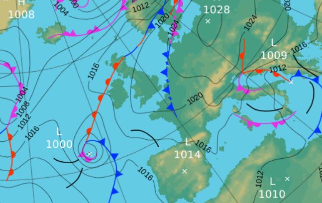
The main action was to come on the 13th as a band of heavy and thundery rain moved north from out of France. At 24.4°c (75.9°f) it felt increasingly oppressive as the day progressed with the thunderstorm arriving during the evening and which gave a lengthy spell of quite vivid lightning and loud thunder; the rain (13.5 mm) that accompanied it was heavy at times.
The warm and humid conditions persisted with the 14-15th both seeing some weak and hazy sunshine after misty starts to the day. Come the 15th in a slack pressure gradient with barely a breath of wind and LP systems surrounding the UK, a month's high temperature of 24.7°c (76.5°f) was reached.
At the half way point of the month the mean temperature was running at 15.8°c, over 1° more than the warmest month of 2016. The second half of the month would now see a return to near normal temperatures.
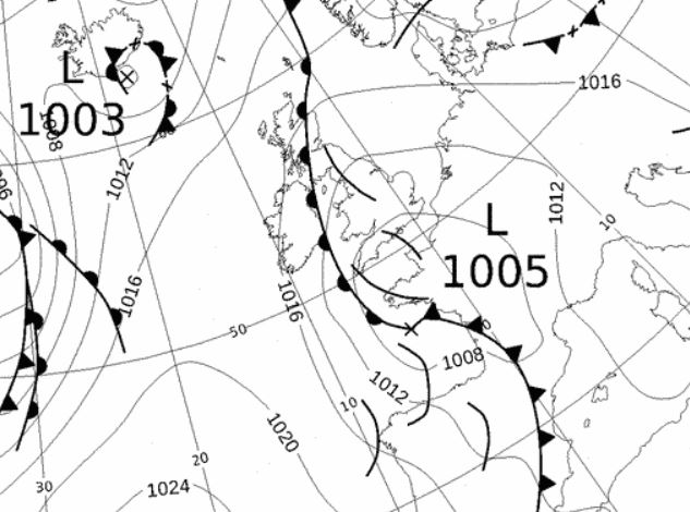 1800 Hrs 13th - the warm, unstable airflow with numerous trough lines that brought the thunderstorm
16th - 23rd After the warmth of the previous days it then took on a much fresher feel as a cold front moved through, followed by a NW'ly flow over the top of HP to our SW. Subsequently the 16th only saw 16.6°c, well down on the previous day, albeit without the humidity and with some sunny spells.
Under a weak ridge of HP the next few days through to and including the 20th were generally dry (drizzle and light rain overnight 18-19th gave 1.4 mm) and enjoyed some sunny periods. Day-time temperatures fell back to within the range of 15-17° during this time.
A cold front connected to LP over Iceland moved west-east late on the 21st and into the early hours of the 22nd to give 11.3 mm of rain and once again behind that front it felt that bit cooler and fresher.
The period ended with HP over the continent trying to nudge west, giving a dry day, but the presence of fronts to our west provided for a cloudy day.
24th - 30th It became that bit more unsettled through to the end of the month with rain on every day and temperatures on most days falling to just above 14°c.
LP was generally in the ascendency starting with a cold front in the early hours of the 25th that gave 10.0 mm of rain (credited back to the 24th). The days were then cloudy with either showers or spells of drizzle or light rain.
The 28th was a dull and murky day with drizzle throughout as LP west of Eire tracked NE and which would have strong winds on its southern flank. A cold front associated to that LP passed over during the night and gave a spell of rain totalling 10.8 mm and brought with it winds gusting to 40 mph.
With HP over the continent and the LP to our north, we stayed in a brisk SW'ly flow at the end of the month and temperatures finally below average.
Rainfall totalled 99.6 mm for the month, with rain recorded on 20 days of which 13 were 'Wet days' (1.0mm +).
The Mean Temperature for the month was 14.08°c -- The Mean Max' was 17.74°c -- The Mean Min' 10.42°c.
We had 0 Air Frosts in the month (year 39) -- Grass frosts totalled 0 (year 83).
The 1 foot soil temp ranged from a low of 13.6°c on the 30th to a high of 16.9°c on the 8th -- with a monthly mean of 15.3°c
The 1 meter soil temp ranged from a low of 13.7°c on the 29th to a high of 14.8°c on the 10th -- with a monthly mean of 14.4°c
COMPARISONS:-
* September 2016 rainfall was 132.3% of the September average for 2007 - 2015
* September 2016 was 1.67°c warmer than the September average for 2009 - 2015 and 1.8°c warmer than the local long term average 1981-2010
* 2015 Jan - Sept TEMP 8.92°c -- RAIN 786.3 mm
* 2014 Jan - Sept TEMP 10.37°c -- RAIN 970.0 mm
* 2013 Jan - Sept TEMP' 8.96°c -- RAIN 703.3 mm
* 2012 Jan - Sept TEMP' 9.25°c -- RAIN 868.5 mm
* 2011 Jan - Sept TEMP' 9.62°c -- RAIN 904.5 mm
* 2010 Jan - Sept TEMP' 8.74°c -- RAIN 461.1 mm
* 2009 Jan - Sept TEMP' 9.77°c -- RAIN 791.9 mm
* 2008 Jan - Sept TEMP' -- RAIN 985.7 mm
This makes the Jan' to Sept' period of 2016 0.37°c warmer than the average for 2009-15 and with 110.7% of average rainfall for 2008-15
JANUARY 2010
FEBRUARY 2010
MARCH 2010
APRIL 2010
MAY 2010
JUNE 2010
JULY 2010
AUGUST 2010
SEPTEMBER 2010
OCTOBER 2010
NOVEMBER 2010
DECEMBER 2010
JANUARY 2011
FEBRUARY 2011
MARCH 2011
APRIL 2011
MAY 2011
JUNE 2011
JULY 2011
AUGUST 2011
SEPTEMBER 2011
OCTOBER 2011
NOVEMBER 2011
DECEMBER 2011
JANUARY 2012
FEBRUARY 2012
MARCH 2012
APRIL 2012
MAY 2012
JUNE 2012
JULY 2012
AUGUST 2012
SEPTEMBER 2012
OCTOBER 2012
NOVEMBER 2012
DECEMBER 2012
SUMMER 2012
REVIEW OF 2012
JANUARY 2013
FEBRUARY 2013
MARCH 2013
APRIL 2013
MAY 2013
JUNE 2013
JULY 2013
AUGUST 2013
SEPTEMBER 2013
OCTOBER 2013
NOVEMBER 2013
DECEMBER 2013
REVIEW OF 2013
JANUARY 2014
FEBRUARY 2014
MARCH 2014
APRIL 2014
MAY 2014
JUNE 2014
JULY 2014
AUGUST 2014
SEPTEMBER 2014
OCTOBER 2014
NOVEMBER 2014
DECEMBER 2014
WINTER 2014
REVIEW OF 2014
JANUARY 2015
FEBRUARY 2015
MARCH 2015
APRIL 2015
MAY 2015
JUNE 2015
JULY 2015
AUGUST 2015
SEPTEMBER 2015
OCTOBER 2015
NOVEMBER 2015
DECEMBER 2015
REVIEW OF 2015
JANUARY 2016
FEBRUARY 2016
MARCH 2016
APRIL 2016
MAY 2016
JUNE 2016
JULY 2016
AUGUST 2016
© Darren Rogers 2016
Want to comment on this site? email